What are Equatorial Plasma Bubbles (EPBs)? - Geography | UPSC Learning
Topics
0 topics • 0 completed
🔍
No topics match your search

What are Equatorial Plasma Bubbles (EPBs)?
Medium⏱️ 10 min read
geography
📖 Introduction
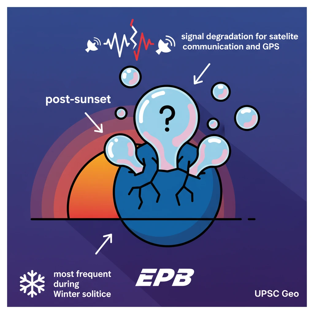
<h4>Equatorial Plasma Bubbles (EPBs)</h4><p><strong>Equatorial Plasma Bubbles (EPBs)</strong> are significant <strong>ionospheric phenomena</strong>. They are generated through <strong>plasma instabilities</strong>, specifically within the <strong>equatorial ionosphere</strong>.</p><div class='info-box'><p><strong>Definition:</strong> <strong>EPBs</strong> are regions of <strong>depleted plasma</strong> in the <strong>ionosphere</strong>. They typically form near the <strong>magnetic equator</strong> during <strong>post-sunset hours</strong>.</p></div><p>These bubbles originate in the <strong>equatorial ionosphere</strong> but possess the capability to extend, influencing the <strong>global ionosphere</strong> within a range of <strong>15° North and South</strong> of the Earth’s equator.</p><h4>Impact on Radio Wave Propagation</h4><p>The presence of <strong>EPBs</strong> has a notable impact on <strong>radio wave propagation</strong>. As radio waves traverse the <strong>ionosphere</strong>, the irregularities linked with <strong>EPBs</strong> can scatter these waves.</p><div class='key-point-box'><p>This scattering effect leads directly to <strong>signal degradation</strong>. It represents a major concern for various communication systems, particularly those that depend on <strong>high-frequency radio waves</strong>.</p></div><p>Such critical systems include <strong>satellite communications</strong> and the <strong>Global Positioning System (GPS)</strong>, where signal integrity is paramount.</p><h4>Seasonal and Regional Variability of EPBs</h4><p>The occurrence of <strong>EPBs</strong> exhibits distinct <strong>seasonal and regional variability</strong>. Their frequency is not constant throughout the year.</p><div class='info-box'><p><strong>Frequency:</strong> <strong>EPBs</strong> are observed to be most frequent during the <strong>Winter solstice</strong> (around <strong>December 21st or 22nd</strong>). Conversely, they are least frequent during the <strong>Summer solstice</strong> (around <strong>June 21st</strong>).</p></div><h4>Hunga Tonga-Hunga Ha'apai Volcano</h4><p>The <strong>Hunga Tonga-Hunga Ha'apai Volcano</strong> is an <strong>undersea volcanic eruption</strong> site. It is associated with two small, uninhabited islands named <strong>Hunga-Ha'apai</strong> and <strong>Hunga-Tonga</strong>.</p><div class='info-box'><p>This volcano has a history of erupting regularly over the past few decades. However, the <strong>January 2022 eruption</strong> was exceptionally massive, considered one of the largest explosions the volcano can produce roughly every <strong>thousand years</strong>.</p></div><p>One of the primary reasons for its highly explosive nature is the phenomenon known as <strong>Fuel-Coolant Interaction</strong>, where molten rock rapidly interacts with seawater.</p><div class='key-point-box'><p>A unique characteristic of the <strong>Hunga Tonga eruption</strong> was its injection of a massive amount of <strong>water vapour</strong> directly into the <strong>stratosphere</strong>. This differs significantly from typical volcanic eruptions.</p></div><p>Usually, volcanic smoke predominantly contains <strong>sulphur dioxide</strong>. This gas typically leads to a temporary cooling effect on the Earth's surface.</p><div class='info-box'><p><strong>Typical Volcanic Cooling:</strong> <strong>Sulphur dioxide</strong> transforms into <strong>sulphate aerosols</strong>, which then reflect sunlight back into space. This process causes the surface to cool until the sulphate settles or is washed out by rain.</p></div><h4>Wayanad Landslides (July 2024)</h4><p>A recent study, published in <strong>Nature Natural Hazards</strong> in <strong>July 2024</strong>, highlighted the <strong>Wayanad landslides</strong>. This study underscores the urgent need for enhanced <strong>disaster management strategies</strong> in vulnerable areas.</p><p>In <strong>July 2024</strong>, the <strong>Wayanad district</strong> in <strong>Kerala</strong> experienced a devastating <strong>landslide disaster</strong>. This event was primarily triggered by a combination of <strong>extreme rainfall</strong> and the region's inherently <strong>fragile ecological conditions</strong>.</p><h4>Causes and Terrain Characteristics</h4><div class='info-box'><p><strong>Wayanad's Terrain:</strong> The region's terrain is characterized by a <strong>soil layer</strong> situated over <strong>hard rocks</strong>. Intense rainfall saturates this soil, significantly weakening its bond with the underlying rocks, thereby precipitating landslides.</p></div><p>The recent warming of the <strong>Arabian Sea</strong> has contributed to the formation of <strong>deep cloud systems</strong>. This has resulted in extremely heavy rainfall in the <strong>Western Ghats</strong>, consequently elevating the risk of landslides.</p><p>Furthermore, <strong>climate change</strong> has caused a shift in the <strong>rain-bearing belt</strong>. This has led to an increase in <strong>convective rainfall</strong> in southern regions such as <strong>Wayanad</strong>.</p><div class='info-box'><p><strong>Convective Rainfall:</strong> This type of rainfall occurs when heated air, laden with water vapor, rises, condenses at higher altitudes, and releases rainfall in the same area without being carried away by wind.</p></div><h4>What are Landslides?</h4><div class='info-box'><p><strong>Definition:</strong> A <strong>landslide</strong> is defined as the <strong>downward movement</strong> of <strong>rock, soil, and debris</strong> along a slope. These movements can be triggered by a variety of factors.</p></div><p>Common triggers include <strong>heavy rainfall, earthquakes, volcanic activity, human activities</strong>, and changes in <strong>groundwater levels</strong>.</p><h4>Types of Landslides</h4><ul><li><strong>Slides:</strong> This type of landslide involves movement along a distinct <strong>rupture surface</strong>. Slides can be further categorized into:<ul><li><strong>Rotational slides:</strong> Movement occurs along a curved rupture surface.</li><li><strong>Translational slides:</strong> Movement occurs along a relatively planar rupture surface.</li></ul></li></ul>

💡 Key Takeaways
- •EPBs are plasma depletions in the equatorial ionosphere, forming post-sunset, affecting radio waves.
- •EPBs cause signal degradation for satellite communication and GPS, most frequent during Winter solstice.
- •Hunga Tonga-Hunga Ha'apai is an undersea volcano; its 2022 eruption was massive, injecting significant water vapour into the stratosphere.
- •Wayanad landslides (July 2024) were triggered by extreme rainfall, fragile terrain, and climate change-induced convective rainfall.
- •Landslides are downward movements of rock/soil/debris, intensified by human activity and climate change.
- •Effective disaster management and understanding climate impacts are crucial for mitigating natural hazards like landslides and volcanic eruptions.
🧠 Memory Techniques
95% Verified Content