Other Geophysical Phenomenon Similar to Polar Vortex - Geography | UPSC Learning
Topics
0 topics • 0 completed
🔍
No topics match your search
Other Geophysical Phenomenon Similar to Polar Vortex
Medium⏱️ 8 min read
geography
📖 Introduction
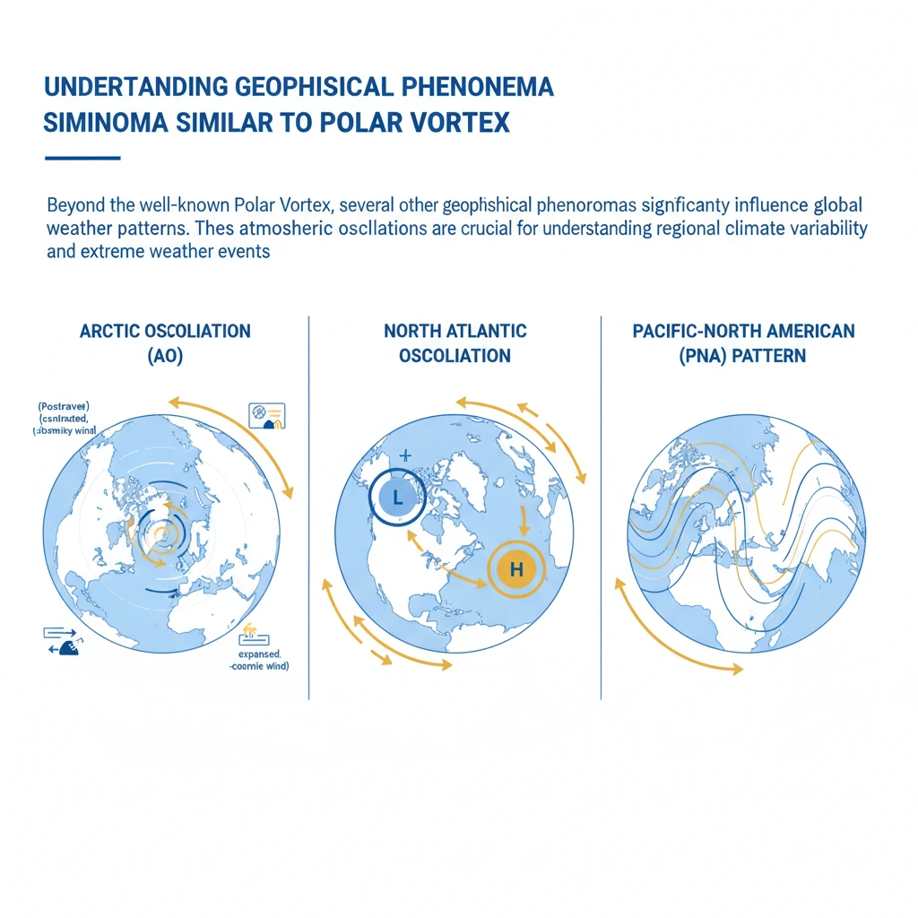
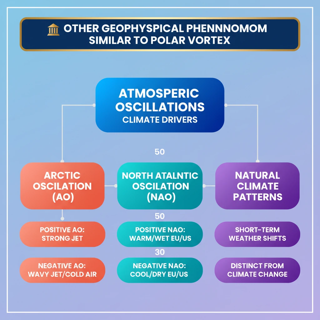
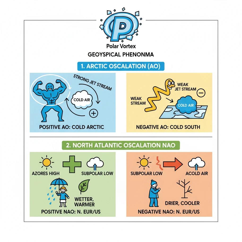
<h4>Understanding Geophysical Phenomena Similar to Polar Vortex</h4><p>Beyond the well-known <strong>Polar Vortex</strong>, several other <strong>geophysical phenomena</strong> significantly influence global weather patterns. These atmospheric oscillations are crucial for understanding regional climate variability and extreme weather events.</p><div class='exam-tip-box'><p>Understanding these oscillations is vital for <strong>UPSC Geography (GS Paper 1)</strong> and <strong>Environment (GS Paper 3)</strong>, especially for questions related to climate change and atmospheric dynamics.</p></div><h4>Arctic Oscillation (AO)</h4><p>The <strong>Arctic Oscillation (AO)</strong> is a prominent <strong>climate pattern</strong> primarily impacting <strong>winter weather</strong> across the <strong>Northern Hemisphere</strong>. It describes the opposing atmospheric pressure patterns between the Arctic and the mid-latitudes.</p><div class='info-box'><p>The <strong>Arctic Oscillation</strong> is characterized by fluctuations in the strength of the <strong>polar vortex</strong> and the position of the <strong>jet stream</strong> around the Arctic.</p></div><h4>Positive Phase of AO</h4><p>During the <strong>positive phase</strong> of the <strong>Arctic Oscillation</strong>, atmospheric pressure is lower over the <strong>Arctic</strong> and higher over the <strong>mid-latitudes</strong>. This pressure difference strengthens the <strong>jet stream</strong>.</p><div class='key-point-box'><p>A strong <strong>jet stream</strong> effectively traps cold air over the <strong>Arctic region</strong>, directing storms northward. This limits significant <strong>cold air outbreaks</strong> in the <strong>mid-latitudes</strong>, leading to milder winters there.</p></div><h4>Negative Phase of AO</h4><p>Conversely, the <strong>negative phase</strong> of the <strong>Arctic Oscillation</strong> involves higher pressure over the <strong>Arctic</strong> and lower pressure in the <strong>mid-latitudes</strong>. This weakens and often displaces the <strong>jet stream</strong>.</p><div class='key-point-box'><p>A weakened and southward-shifted <strong>jet stream</strong> allows frigid <strong>Arctic air</strong> to spill into the <strong>mid-latitudes</strong>. This results in severe <strong>cold outbreaks</strong> and increased storm activity in regions like <strong>North America</strong> and <strong>Europe</strong>.</p></div><h4>North Atlantic Oscillation (NAO)</h4><p>The <strong>North Atlantic Oscillation (NAO)</strong> is another critical <strong>climate pattern</strong> influencing weather across the <strong>North Atlantic basin</strong>. It specifically measures the difference in <strong>sea-level pressure</strong>.</p><div class='info-box'><p>The <strong>NAO</strong> is defined by the pressure anomaly between the <strong>Azores High</strong> (a persistent subtropical high-pressure system) and the <strong>Subpolar Low</strong> (a persistent low-pressure system near Iceland).</p></div><h4>Positive Phase of NAO</h4><p>In the <strong>positive phase</strong> of the <strong>North Atlantic Oscillation</strong>, both the <strong>Azores High</strong> and the <strong>Subpolar Low</strong> are stronger than average. This creates a steeper pressure gradient across the North Atlantic.</p><div class='key-point-box'><p>This stronger gradient enhances the <strong>westerly winds</strong>, leading to <strong>warmer</strong> and <strong>wetter conditions</strong> across the eastern <strong>United States</strong> and northern <strong>Europe</strong>. Conversely, southern Europe experiences drier conditions.</p></div><h4>Negative Phase of NAO</h4><p>The <strong>negative phase</strong> of the <strong>North Atlantic Oscillation</strong> is characterized by weaker than average <strong>Azores High</strong> and <strong>Subpolar Low</strong>. This reduces the pressure difference across the North Atlantic.</p><div class='key-point-box'><p>A weaker pressure gradient results in a southward shift of the <strong>storm track</strong>. This typically brings <strong>cooler</strong> and <strong>drier conditions</strong> to the eastern <strong>United States</strong> and northern <strong>Europe</strong>, while southern Europe may experience increased rainfall.</p></div>
💡 Key Takeaways
- •<strong>Arctic Oscillation (AO)</strong> affects Northern Hemisphere winter weather by influencing the jet stream and polar vortex.
- •<strong>Positive AO</strong> means a strong jet stream, trapping cold air in the Arctic; <strong>Negative AO</strong> means a weak, wavy jet stream, allowing cold air to spill south.
- •<strong>North Atlantic Oscillation (NAO)</strong> measures pressure differences between the Azores High and Subpolar Low, impacting North American and European weather.
- •<strong>Positive NAO</strong> brings warmer, wetter conditions to northern Europe/US; <strong>Negative NAO</strong> brings cooler, drier conditions.
- •These oscillations are natural climate patterns, crucial for understanding short-term climate variability and extreme weather events, distinct from long-term climate change trends.
🧠 Memory Techniques
95% Verified Content
📚 Reference Sources
•National Oceanic and Atmospheric Administration (NOAA) Climate Prediction Center (for AO/NAO details)
•NASA Earth Observatory (for general climate pattern information)