What are the Key Facts About Kosi River and Mechi River? - Geography | UPSC Learning
Topics
0 topics • 0 completed
🔍
No topics match your search
What are the Key Facts About Kosi River and Mechi River?
Medium⏱️ 8 min read
geography
📖 Introduction
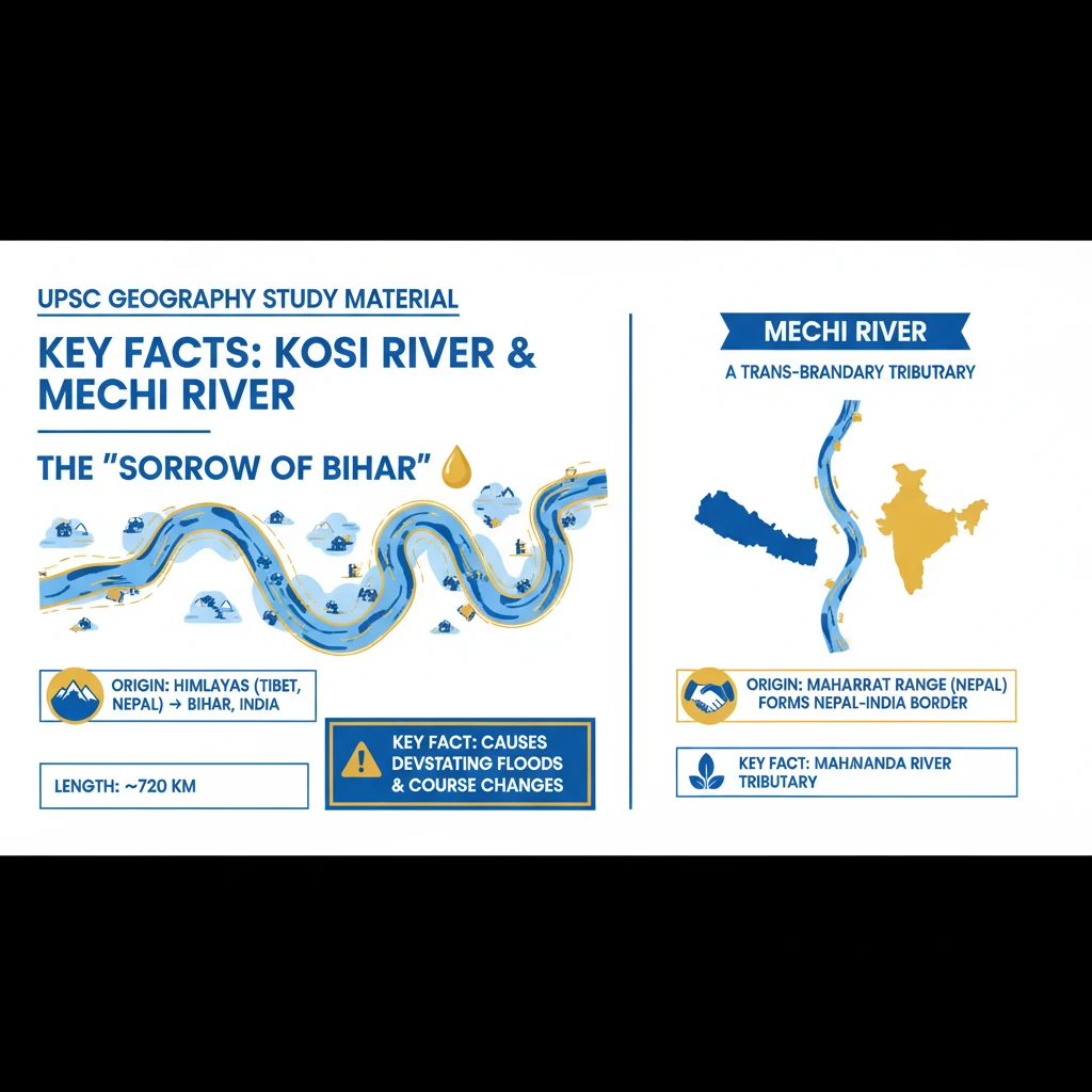
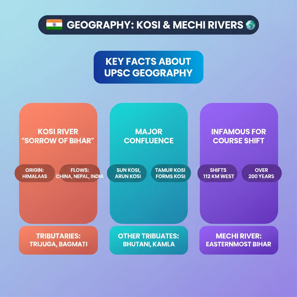
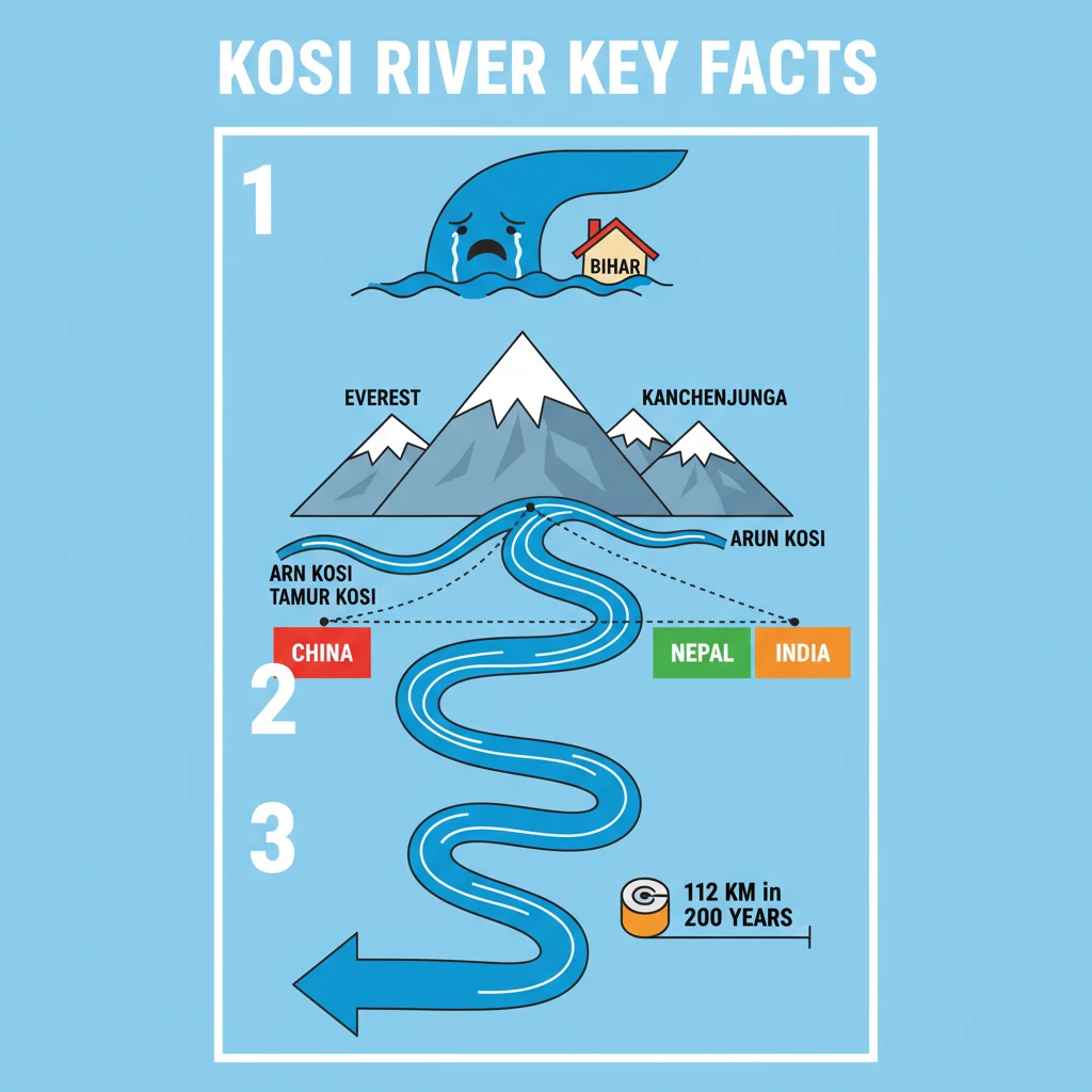
<h4>Introduction to Kosi River</h4><p>The <strong>Kosi River</strong> is famously known as the <strong>“Sorrow of Bihar”</strong> due to its devastating floods and frequent course changes. It is a significant trans-boundary river in the Indian subcontinent.</p><div class='key-point-box'><p><strong>Key Fact:</strong> The <strong>Kosi River</strong> is often referred to as the <strong>“Sorrow of Bihar”</strong>.</p></div><h4>Origin and Course</h4><p>The <strong>Kosi River</strong> originates in the majestic <strong>Himalayas</strong>, at an elevation exceeding <strong>7,000 metres</strong> above sea level. Its catchment area lies within the vicinity of prominent peaks like <strong>Mount Everest</strong> and <strong>Kanchenjunga</strong>.</p><p>The river traverses through three countries: <strong>China</strong>, <strong>Nepal</strong>, and <strong>India</strong>. It makes its entry into India near <strong>Hanuman Nagar</strong>.</p><div class='info-box'><ul><li><strong>Origin:</strong> Over <strong>7,000 metres</strong> in the <strong>Himalayas</strong>.</li><li><strong>Catchment Area:</strong> Near <strong>Mount Everest</strong> and <strong>Kanchenjunga</strong>.</li><li><strong>Countries Flowing Through:</strong> <strong>China</strong>, <strong>Nepal</strong>, <strong>India</strong>.</li><li><strong>Entry into India:</strong> Near <strong>Hanuman Nagar</strong>.</li></ul></div><p>Ultimately, the <strong>Kosi River</strong> merges with the mighty <strong>Ganga River</strong> near <strong>Kursela</strong>, located in the <strong>Katihar district</strong> of <strong>Bihar</strong>.</p><h4>Formation and Main Streams</h4><p>The <strong>Kosi River</strong> is not a single stream at its origin but is formed by the confluence of three primary tributaries. These streams unite to form the main river channel.</p><div class='info-box'><p>The <strong>Kosi River</strong> is formed by the confluence of:</p><ul><li><strong>Sun Kosi</strong></li><li><strong>Arun Kosi</strong></li><li><strong>Tamur Kosi</strong></li></ul></div><h4>Characteristic: Course Shifting</h4><p>One of the most defining characteristics of the <strong>Kosi River</strong> is its notorious tendency to frequently shift its course. This phenomenon has significant geological and socio-economic impacts.</p><p>Over the past <strong>200 years</strong>, the river has dramatically moved its course approximately <strong>112 km</strong> towards the <strong>west</strong>. This westward migration has led to widespread devastation.</p><div class='key-point-box'><p><strong>Impact:</strong> The river's course shifting has severely affected agricultural lands in districts such as <strong>Darbhanga</strong>, <strong>Saharsa</strong>, and <strong>Purnea</strong> in <strong>Bihar</strong>.</p></div><h4>Major Tributaries</h4><p>During its journey through the plains, the <strong>Kosi River</strong> is joined by several important tributaries. These rivers contribute significantly to its volume and discharge.</p><div class='info-box'><p>Key tributaries of the <strong>Kosi River</strong> include:</p><ul><li><strong>Trijuga</strong></li><li><strong>Bhutani Balan</strong></li><li><strong>Kamla Balan</strong></li><li><strong>Bagmati</strong></li></ul></div><h4>Note on Mechi River</h4><p>While the topic mentions the <strong>Mechi River</strong>, the provided source material primarily focuses on the <strong>Kosi River</strong>. Detailed facts about the <strong>Mechi River</strong> are not available in the given text.</p><div class='exam-tip-box'><p>For UPSC preparation, it is crucial to gather comprehensive information on all mentioned topics. If <strong>Mechi River</strong> facts are required, consult additional geographical sources.</p></div>
💡 Key Takeaways
- •Kosi River is known as the "Sorrow of Bihar" due to devastating floods.
- •Originates in the Himalayas near Mount Everest and Kanchenjunga, flows through China, Nepal, and India.
- •Formed by the confluence of Sun Kosi, Arun Kosi, and Tamur Kosi.
- •Notorious for shifting its course westward, moving 112 km in 200 years.
- •Major tributaries include Trijuga, Bhutani Balan, Kamla Balan, and Bagmati.
- •Its instability significantly impacts agriculture and livelihoods in Bihar.
🧠 Memory Techniques
95% Verified Content