Baselines: Defining Maritime Zones & Internal Waters - Geography | UPSC Learning
Topics
0 topics • 0 completed
🔍
No topics match your search
Baselines: Defining Maritime Zones & Internal Waters
Medium⏱️ 7 min read
geography
📖 Introduction
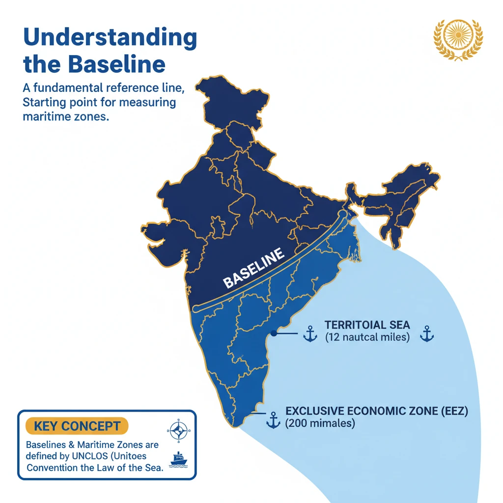
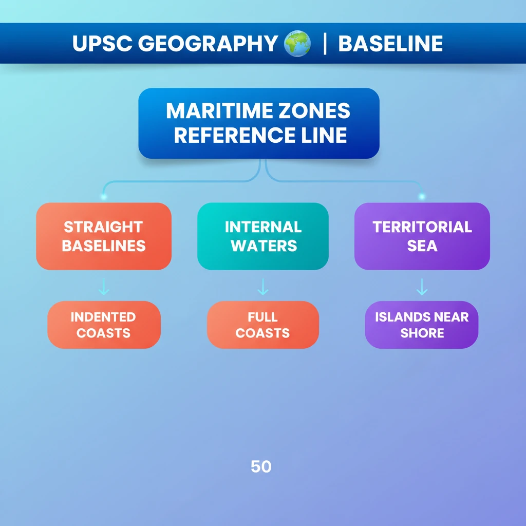
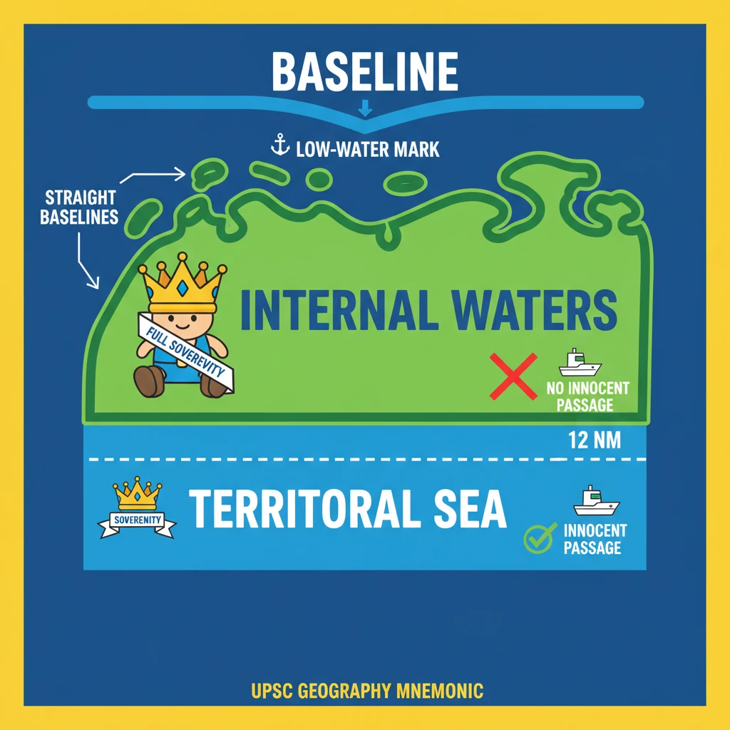
<h4>Understanding the Baseline</h4><p>A <strong>baseline</strong> is a fundamental reference line, typically drawn along a nation's <strong>coastline</strong>. Its primary purpose is to serve as the starting point for measuring the outer limits of a state's various <strong>maritime zones</strong>, including its <strong>territorial sea</strong> and <strong>exclusive economic zone (EEZ)</strong>.</p><div class='info-box'><p>The concept of <strong>baselines</strong> and <strong>maritime zones</strong> is primarily governed by the <strong>United Nations Convention on the Law of the Sea (UNCLOS)</strong>, a landmark international treaty.</p></div><p>Normally, this <strong>baseline</strong> aligns with the <strong>low-water mark</strong> along the coast, representing the lowest tide level. This method is used for relatively smooth and stable coastlines.</p><h4>Straight Baselines: Special Cases</h4><p>In specific geographical situations, an alternative approach known as <strong>straight baselines</strong> may be adopted. This occurs when the coastline is highly <strong>indented</strong>, features numerous <strong>islands close to the shore</strong>, or exhibits significant <strong>instability</strong> due to geological factors.</p><div class='key-point-box'><p><strong>Straight baselines</strong> connect selected points along the coast or outer islands, effectively enclosing areas that would otherwise be considered high seas, thereby creating <strong>internal waters</strong>.</p></div><h4>Internal Waters: Full Sovereignty</h4><p><strong>Internal waters</strong> are defined as all waters situated on the <strong>landward side</strong> of the established <strong>baseline</strong>. These are the closest maritime areas to a state's land territory.</p><p>A coastal state exercises <strong>full sovereignty</strong> over its <strong>internal waters</strong>, akin to its land territory. This means it has complete control and jurisdiction over these areas.</p><div class='info-box'><p>Examples of <strong>internal waters</strong> include <strong>bays</strong>, <strong>ports</strong>, <strong>inlets</strong>, <strong>rivers</strong>, and even <strong>lakes</strong> that are connected to the sea. These areas are considered an integral part of the state.</p></div><p>A crucial aspect of <strong>internal waters</strong> is that there is <strong>no right to innocent passage</strong> through them. This means foreign vessels cannot pass through without the explicit permission of the coastal state.</p><h4>Territorial Sea: Limited Sovereignty</h4><p>The <strong>territorial sea</strong> extends seaward from the <strong>baselines</strong> up to a maximum distance of <strong>12 nautical miles (nm)</strong>. This zone is a direct extension of the state's sovereignty.</p><div class='info-box'><p>Within the <strong>territorial sea</strong>, coastal states possess <strong>sovereignty</strong> and <strong>jurisdiction</strong>. These rights encompass not only the water surface but also the <strong>seabed</strong>, <strong>subsoil</strong>, and the <strong>airspace</strong> above it.</p></div><p>However, the coastal state's rights in the <strong>territorial sea</strong> are subject to a significant limitation: the <strong>right to innocent passage</strong>. Foreign vessels are generally allowed to pass through, provided their passage is not prejudicial to the peace, good order, or security of the coastal state.</p><h4>Contiguous Zone: Preventive Rights</h4><p>The <strong>contiguous zone</strong> is an area adjacent to and extending beyond the <strong>territorial sea</strong>. It stretches seaward up to <strong>24 nm</strong> from the <strong>baselines</strong>, creating an intermediary area between the territorial sea and the high seas.</p><p>In this zone, the coastal state has specific rights to <strong>prevent and punish infringement</strong> of its <strong>fiscal</strong>, <strong>immigration</strong>, <strong>sanitary</strong>, and <strong>customs laws</strong>. These laws must have been violated within its territory or territorial sea.</p><div class='key-point-box'><p>Unlike the <strong>territorial sea</strong>, the <strong>contiguous zone</strong> grants jurisdiction only over the <strong>ocean's surface</strong> and <strong>floor</strong>. It does <strong>not provide air and space rights</strong> to the coastal state.</p></div><h4>Exclusive Economic Zone (EEZ): Resource Rights</h4><p>Each coastal state has the right to claim an <strong>Exclusive Economic Zone (EEZ)</strong>. This zone extends beyond and adjacent to its <strong>territorial sea</strong>, reaching up to <strong>200 nm</strong> from its <strong>baselines</strong>.</p><p>Within its <strong>EEZ</strong>, a coastal state holds <strong>sovereign rights</strong> primarily for the purpose of <strong>exploring, exploiting, conserving, and managing natural resources</strong>. This includes both <strong>living and nonliving resources</strong> found in the <strong>seabed</strong>, <strong>subsoil</strong>, and overlying waters.</p><div class='info-box'><p>The <strong>EEZ</strong> also grants rights to engage in other economic activities, such as the <strong>production of energy</strong> from water, currents, and wind. This allows for renewable energy projects.</p></div><p>It is important to note that the <strong>EEZ</strong> primarily grants <strong>resource rights</strong>. Unlike the <strong>territorial sea</strong> and <strong>contiguous zone</strong>, it does not give a coastal state the right to prohibit or significantly limit <strong>freedom of navigation</strong> or <strong>overflight</strong> for other nations, with only limited exceptions.</p><h4>Continental Shelf: Geological Extension</h4><p>A <strong>continental shelf</strong> represents the natural geological extension of a continent beneath the ocean. It extends from the <strong>coastline</strong> out to a distinct drop-off point known as the <strong>shelf break</strong>.</p><p>Beyond the <strong>shelf break</strong>, the seafloor descends more steeply into the deep ocean basin, forming what is called the <strong>continental slope</strong>. This geological feature is distinct from the legal maritime zones, though related.</p><h4>High Seas: Common Heritage</h4><p>The areas of the <strong>ocean surface</strong> and the <strong>water column</strong> that lie beyond the outer limits of a state's <strong>EEZ</strong> are collectively referred to as the <strong>high seas</strong>. These vast areas are beyond any single national jurisdiction.</p><div class='key-point-box'><p>The <strong>high seas</strong> are considered the <strong>“common heritage of all mankind.”</strong> This principle implies that these areas should be used peacefully and for the benefit of all nations.</p></div><p>States are permitted to conduct various activities in the <strong>high seas</strong>, provided these activities are for <strong>peaceful purposes</strong>. This includes activities such as <strong>transit</strong>, <strong>marine science research</strong>, and <strong>undersea exploration</strong>, all subject to international law.
💡 Key Takeaways
- •A Baseline is the reference line for measuring all maritime zones, typically the low-water mark.
- •Straight Baselines are used for deeply indented coastlines or islands close to shore.
- •Internal Waters are landward of the baseline; coastal states have full sovereignty with no innocent passage.
- •Territorial Sea extends 12 nm from the baseline; coastal states have sovereignty but must allow innocent passage.
- •Contiguous Zone extends 24 nm from the baseline; states can prevent/punish fiscal, immigration, sanitary, customs infringements.
- •Exclusive Economic Zone (EEZ) extends 200 nm from the baseline; states have sovereign rights for resource exploration and exploitation.
- •High Seas are beyond the EEZ, considered 'common heritage of all mankind' with freedom of navigation.
🧠 Memory Techniques
98% Verified Content
📚 Reference Sources
•Drishti IAS Study Material on Maritime Zones
•Ministry of External Affairs, Government of India (Maritime Zones Act, 1976)
•International Court of Justice (ICJ) rulings on maritime delimitation